Greetings, Friends, and welcome to another ramble through the Arizona desert with me. Today, Sunday, April 13, 2014, I have returned to the urban wilderness of the Salt River greenbelt about 2 miles south of downtown Phoenix. This is literally a couple of miles of what the Salt River would have been like before 6 dams got built on it upstream that diverted every bit of water into irrigation canals and city water supplies. It has water now because the City of Phoenix pumps some waste water back into it, thus creating a number of pools and a little bit of running water. We have been walking in this park before, and will probably go again. It is one of my favorite places around Phoenix. I had two motives for visiting it today. 1. I need a 2 or 3 mile walk every day for my health, and it sure would be nice to get some of those walks somewhere other than around my slummy neighborhood. 2. Lately, I’ve been questing for striped stones. I’ll tell you more about that in tomorrow’s blog, but riverbeds are a good place to look for them. The river cuts through many different sorts of terrain and has carried many different types of rocks downstream with it, mixing them all up in the process. A place that is all the same kind of rock is not a very good hunting ground when you want a variety of rocks
This is actually a good deal for you, dear Reader, as you get to see the best of what I saw on what was about 3 miles of meandering without the actual negative effects of getting sore feet along with being hot and sweaty. Ready? Let’s go!

I entered the park at the northeast entrance on 7th Avenue. Once beyond the parking lot, I found a sign that gave me my choices. I decided to go east toward Central.
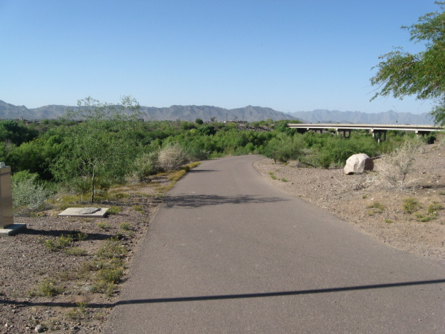
I am looking sort of southwest from here. The nearer range of hills is part of South Mountain Park, and the farther range is called the Estrellas. (Estrellas is Spanish for stars.) There’s a bridge. I’m a troll. Trolls love bridges, so you’ll see a lot of bridge photos when I go walking. 🙂

There is an asphalt access road here for the use of park rangers. I decide to make the walking easier for myself by staying on the paved area, at least at the beginning. The hill in the distance marks the western edge of Tempe.

Looking down at the river. I’m staring at it to see if I can locate the source of a strange honking noise coming from somewhere down there. Might be a goose, or a bullfrog, or a river monster. I’m not that great at identifying animal noises.

Still hearing the honking. Sometime I would like to come out here with a tape recorder and just collect weird noises.

I stopped here because of the rock field. I collected my first striper here, a hefty fellow that probably weighs about 5 pounds. Then I got distracted by the pretty flowers. This is desert spring–when the cacti flower. The broad-leafed cactus you see is a prickly pear. It has an edible fruit, and some lovely orange and gold flowers.

A closer look at the flowers from right above them on a different cactus. Yikes! There are bees in some of these flowers. Stay calm. Don’t bother them, and they won’t bother me. You will be happy to know that I did not get stung.

I really am not very far from downtown Phoenix. This is a telefoto shot, but the high-rises are probably less than 2 miles away.

Here’s another shot toward town. The double arches you see are the east and west ends of Chase Field where the Arizona Diamondbacks play baseball. The roof is open The tall peak you see in the distance is Piestawa Peak, renamed about 10 or 15 years ago (time flies when you’re not paying attention) for an Arizona Native American woman who was killed while serving with our armed forces during the Iraq war. Before the Arizona Legislature changed its name, this big hill was called Squaw Peak.

A better shot of Phoenix without the iron fence in the way. I kind of love to take pictures of my hometown city, so you will probably see a lot of them if you keep reading this blog.

Woo hoo! Arizona sky and a jet heading for Skyharbor airport. I don’t have a really great camera, so I’m kind of surprised I was able to get this good a picture of it.

I came to a fork in the road. The bridge up ahead is on Central Avenue which divides Phoenix into an eastern and a western half. I took the low road . . .
 and found a bridge leading to a bridge!

The small bridge crosses this channel and waterfall bringing water from the city into the river.

Who knew? Walking under the Central Bridge, I found art. This art has a message. Recycle and don’t pollute.

Looking south there’s art in the other direction too.

The next span over has more art. Looking toward the city we see the city. That dates the art as sometime after 1998 when the D-backs and Chase Field both got their start.

Another message: Every Drop Counts was a slogan for water conservation in the desert about 20 years ago.

I like the foreground with all the different kinds of animals you might encounter down here in the river park. Look! There is that prickly pear cactus in bloom that I showed you.

The state flag of Arizona.

What the hey? What are these four broken pillars doing out here?

Here’s another park sign, but with an error. 7th Street might be relatively close, but it’s not four one-hundredths of a mile to the east–more like four tenths of a mile. I had only planned to walk to Central, but with the next bridge only .4 miles away, what the heck? Walk on, Ken!

This path crosses the river. 100 yards to the west is water and a wetland forest. Here it is dry as a bone. I walked across, found a couple more rocks for my collection.

It didn’t take long to reach the 7th Street bridge.
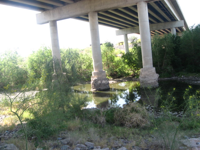
There is an oasis here too, but no art under the bridge.

Ever wonder what the bottom of a bridge looks like? Now you know. When you are down here, the cars passing above you sound like thunder.

I am walking back to the car now. I already have at least 10 pounds of striped stones. I have probably seen a million rocks, and found about ten worth picking up. The camera says the batteries are low. I find this little stream and in my imagination it becomes a wild river leading into an unknown wilderness.

As long as my imagination is running away with me, this iron door becomes the sally port of a castle. This wall looks a bit like the base of a castle tower.
 And the last picture my camera would take is of this beautiful trash can. I tell you, art is everywhere in Phoenix.
The distance between 7th Ave. and 7th Street is 1.2 miles according to the signs. I actually wandered off the straight line several times, so I figure I walked at least 1.5 miles each way, thus making a 3 mile hike.
I took pictures a little while ago of the rocks I found on this expedition. I’ll show them to you in a really dull geology blog tomorrow or sometime soon. Or maybe I’ll just post them on Facebook.
If you would go walking thru urban wilderness with me, why not leave a comment?
–end
On Sunday, September 21, 2012, I decided to get out of my apartment for another early morning hike. I really wanted to see some kind of wildlife, so I went to the one place where I’ve seen a lot of animal life before, the bed of the Salt River that has been turned into a park stretching from 24th Street to 19th Avenue. The City of Phoenix has been adding water back into the riverbed–don’t know if it is waste water or irrigation water or where it comes from, but the City is making about 5 miles of river in the center of the valley. It was a beautiful day for hiking, too bad I was by myself. I brought along my camera, and what follows is my record of my walk. I especially tried to get pictures of animals, so look closely and see if you can spot the beasties my human eye spotted and tried to get on camera. I probably need a better camera for this sort of picture taking. I’m sure Brian’s latest toy would have done a much better job, but I work with what I have.

Although this looks like a view of the parking area where I left my car, and started the walk, it is really included to show the skyline of Phoenix to the north. Maybe I should have climbed up on the wall to get a better angle on it.

Telescopic view of the 7th Avenue bridge with the city beyond it. I have learned to use the telephoto ability of my camera, and sometimes I even remember to do so.

View from beneath the 7th Avenue Bridge.

Daffy Duck? From the south side of the river, one can get much closer to the water.

One of seven pools along this stretch of “river”. It looks natural, but the City’s Parks Department built it. This water is way up above the natural bottom of the river. Pumps must be involved.

For a desert rat like me, this is kind of a strange sight. Peaceful. Kind of makes me wish I could be that duck for a short while.

Access road on the south side of the river. Easy walking.

Side trail leading down to the river.

The heart of the forest. Early in the walk I reached the greenest part of the park.

Looking back toward the 7th Ave. bridge. You can see my trademark shadow in the picture thus proving it was really me taking these pictures.

a hidden pool.

No fishing! It would take a very determined fisherman to get down to the water around here. I wonder what kind of fish, the city has put into the river.

Tangled. I think I was trying to photograph a dragonfly here, but I don’t see it.


Two-headed duck.

First glimpse of Bugs. There’s a rabbit in this picture. Can you find it?

One step closer with the telephoto on.

The road twists and turns. This feels about right for me–the proper mixture between nature and civilization.

This looks like a birch tree to me. You don’t see many birch trees in the Phoenix area. It is too hot and dry for them.

I saw another rabbit, but it blends into the scenery very well. This seems to be the main area for rabbits along this trail. There are probably hundreds of them.

Big scummy pool–i wonder what lurks below the surface.

The ground here is full of holes. Snakes and small rodents live in these, and there is a maze of small tunnels beneath all this vegetation.

There’s a bird in here somewhere.


I met some park rangers. They told me about the seven pools on the river, and about some of the wildlife I didn’t see. They saw a coyote that morning, and there are rumors of beavers living on the river. Back before Arizona was a state, there were plenty of beavers living on Arizona rivers, but they were trapped and hunted to extinction by the mountain men before 1850. I enjoyed my chat with these guys.

Waterfall. I have walked almost all the way to Central Avenue. Water is entering the river here from the south.

West side of the Central Avenue bridge. Central Avenue splits the Phoenix area into eastern and western halves.

The eastern side of the Central Avenue bridge. Note the massive buttresses supporting the bridge. In the past during floods, the bridges supported only by pillars like those at 7th Avenue would often be undermined and crumble, but the Central Avenue bridge never failed.

Anthill. When I was a boy in Phoenix, there were anthills everywhere, and a favorite game was collecting ants in a large bottle and having one’s own ant colony. Now, I go years without seeing anthills sometimes, and if you do find them, they are the tiny black ants. These are red ants, but not the big red fire ants i remember playing with as a child.

- These white flowers look almost like lillies, and were growing along the river wherever the ground was open enough.

Riverbed showing finely sorted pebbles, all about the same size and composition. I saw some kind of desert squirrel here, but it didn’t hold still long enough for me to catch a picture of it.

There were a fair number of butterflies in the air, and there is a yellow butterfly in the center of this picture on the bush. With wings folded it was almost invisible, and you could see right through the filmy yellow wings.

I have reached the 7th Street bridge, about 14 blocks east of where I started. You can tell I am a troll–I have a fondness for being beneath bridges.

View of the river east of 7th Street. There are parking areas here too, and I may come and start my walk from this part of the river some time in the future.

I found this plastic Chevy hubcap at my easternmost part of the walk, off the main road. I’m sorry to say there was plenty of litter in the park. I picked up the hubcap and brought it home with me as a symbol of my walk, and a bit of clean up.
At this point I turned back, and walked as quickly as I could back to my car. I meant to take a few other pictures, but the batteries were low, and the camera refused to work. I had one more encounter, came across a big gray rabbit with a white tail, on my way back. At one point it passed beside me no more than six feet from me, but he was really moving. I saw it clearly, but there was no chance to photo it.
So, there you have it. My animal encounters started with a black duck and ended with a gray rabbit with a white tail. If they aren’t Daffy Duck and Bugs Bunny, two of my cartoon heroes sent to brighten up my day by a benevolent universe, then there is no greater power that caters to the whims of men. Ducks and rabbits are common animals, but being superstitious, I consider their appearance to be a kind of gift. Thank you, World!

The hubcap and the Trollgod’s hat are home now. The hubcap is really too dirty to bring into the house, but it has a position of honor on the concrete wall just outside my front door. The circle is complete, and once again I have returned to the place from which I started.
I hope you have enjoyed my little walk along the Salt River bed. The pictures are nothing special–just a record of a couple of hours in one morning of my life. In this age of computers and high tech, this kind of interaction with the world gets less and less common. Who knows what will be of value, and to whom? I leave this record in hopes that someone, somewhere, somewhen will get something of value from it.
If you know anything about Arizona’s urban wilderness, or even if you don’t, please feel free to leave a comment.
–end
On Sunday, March 25, 2012 I decided to go for a morning hike. My destination was South Mounain, but as I headed in that direction (south, of course, I have to go south to reach South Mountain) on 7th Avenue, I noticed a small city park located in the riverbed of the Salt River. Phoenix, like many large cities is built on a river, but this river has been dammed some 40 miles northeast of town, not once, but several times, creating a series of lakes in the Superstition Mountains, and leaving the river itself dry and empty by the time it reaches Phoenix. I have been wishing for some time that I could walk in the dry riverbed, but it is fenced off at most crossings. Well, I had unexpectedly discovered a place where the riverbed was accessible, and I abandoned the trip to South Mountain to take a hike here. I had brought my camera along to record the trip, and so, on Sunday morning I walked about 5 miles in a difficult, but beautiful, hidden part of the city that most people never see. Here are some of the pictures to show what I found. I took 43–yikes!–but that’s too much to foist upon you, dear reader, in this blog. Your journey will not be quite as long as mine was.

My starting point--looking back at the 7th Avenure bridge over the Salt River. Whenever you see a line of green plants like this, continuous, in the desert, it means there is water there.

A 1-lane road leads down into the riverbed. It doesn't stay paved for very long. I found a city park ranger and a work crew at the bottom and found I had permission to explore this part of the river as much as I wanted.

I headed west. The road quickly ended and left me with this kind of terrain to walk on. Note the incredible variety of rocks present. They have washed and tumbled down to their current locations over millions of years and represent rock from every part of east central Arizona. The line of trees is the actual edge of the flowing river.

I wondered if I could actually get down and walk by the water. All the interesting stuff would be down there. By this time I could hear a lot of strange bird calls. There were occasional quacking noises, and various hoots and tweets, but something sounded like a cow in labor. For all I know there might have been A cow in labor down there, but my guess was for swans or geese. I headed that way. I thought that once I broke through the barrier of dead cattails, I'd be at the riverside.

I reached the edge of the reeds and started to break through them. They were all dry and dead, and broke very easily. Luckily, I looked down, chooosing my footing carefully, before stepping into them. This photo is looking straight down, and the dark stuff you see is river water. One more step and I would have fallen right into the swamp, and that wouldn't have been any fun at all. Oh, yeah, cattails and other reeds actually grow right in the water. You don't break through them to reach the river, not unless you have hip waders and a machete.

I found a place where I could climb out of the riverbed. Off to the side was a huge open pit gravel mine. This pit isn't natural. Men dug it. I guess they dug all the way down to the water level, because the deepest part of the pit is a large pond. Those are the South Mountains in the background.

This isn't river. It's a big open pit full of water.

I reached the greenest part of the river. The trees were largest and thickest here. Bird calls were most numerous. This is whete I actually saw some wildlife. Two large white birds, not ducks or geese, lifted out of the vegetation and flew around, circled, and then headed off upriver. I could not photograph them--they moved too quickly for my little camera. I'm not sure what they were, but they had a kink in their necks and wingspans of six to eight feet--I'm guessing herons or egrets--not birds one expects to see in Arizona. I also saw a large black hawk, skimming near the ground, gliding in the way that raptors do. It passed within 20 feet of me, bigger than a crow, with very dark feathers, and definitely a hooked beak.

My path was blocked by fences. To continue, I would either have to retrace my steps and climb back down into the river bottom, or take this narrow cliff trail. I have fantasized about narrow cliff trails all my life, and here I finally found one in the heart of Phoenix.

I took the cliff trail, of course. Explorer Ken isn't going to let a little thing like a narrow trail keep him from completing his journey. It got narrower as I went along. The cliff is about a 60 to 70 degree slope, all caliche. Falling down it would be painful or fatal. But why would anyone fall?

Secret tunnels leading into the river. Halfway along the cliff trail, I found a road leading back into the riverbed, and a jog in the fence. City of Phoenix owns the fenced-in land. I got back down into the rough terrain. It would have been nice if there were a real road down there, but it was all rocks--only a high-bottomed 4-wheel drive vehicle would want to drive on such terrain.

I set that distant bridge, the one that carries 19th Avenue over the river, as my goal.

Along the way I found this stunted palm tree growing wild in the riverbed.

Walking very carefully over treacherous footing, I reached my goal. Did you ever wonder what the bottom of a bridge looks like? Having gotten this far, I wondered if I could actually cross the river and go back on the other side. I headed across.

On the other side, in a shady grassy area, I found a sleeping bag, and a good deal of trash. Is some homeless person living down here? Could be. I did not take his sleeping bag.

Where does the water in the riverbed come from? There hasn't been enough rain to account for it. It doesn't flow down continuously from upstream. The answer is that the City of Phoenix or the Salt River Project is dumping water into the river. Here is a huge drainage tunnel with lots of water pouring out of it every second.

Then came the hard part--getting back to my car 12 blocks to the east. I thought perhaps I could climb out of the river and walk back on the banks 30 feet above. I tried it here, but about 30 feet up the slope crumbled beneath me so badly that I couldn't go on, slipping and sliding back down to the base.

I found another possible spot to climb out a block or so to the east. It was a hard scramble, but the slope was rockier there, and with difficulty I made it to the top. Here you see me dangling my feet over the edge and looking down at the cliff I had just climbed. Not bad for a 64 year old man.

The cliff trail going this way was even narrower than it had been in the other direction. There were spots where I had to actually hang onto the fence in order to keep from falling off the trail, which crumbled underfoot in places.

Once the cliff trail was behind me, it was an easy walk back the rest of the way. I stayed on top. I was tired of twisting my ankles on the stones below.

It is Spring in Arizona. Desert wildflowers, mostly yellow, are in bloom.

Going out where I first came in. Goodbye to Rio Salado. I look forward to hiking a different part of the river some time in the future.
I showed you 17 of the 43 pictures I took on Sunday. This is a part of the city that not one person in a thousand ever sees, or even thinks about. If you’ve ever found the wilderness still lurking in the heart of your own city or town, or if you’d go hike the river with me some day, why not leave a comment?
–end


 and found a bridge leading to a bridge!


 And the last picture my camera would take is of this beautiful trash can. I tell you, art is everywhere in Phoenix.


